Toward a Btter Solution: New Study Analyzes Insect Resistance in Bt Crops

http://i1.tribune.com.pk/wp-content/uploads/2013/01/499961-corn-1359416071-956-640x480.jpg

In 1983, geneticists inserted a bacterium gene, “Bt” into a plant to create the first inherently pest-resistant crop. Just over a decade later, “Bt” corn was introduced to the US market, and 15 years after that the genetically modified crop made up 67% of corn planted in the US. The crop, which requires no chemical pesticides to resist corn borers and other insects, reduced pesticide use by 18.5 million pounds and saved farmers $139 million in pesticide costs (and that’s just data for 2004).

US producers aren’t the only winners in this story. Worldwide, over 420 million hectares of land are devoted to Bt crops – an over 60-fold increase since 1996 – and producers and consumers globally have enjoyed the benefits. In India, Bt cotton has increased yields by over 30%. In China, annual gains of Bt cotton are estimated at $1 billion. Worldwide, Bt crops have resulted in more efficient use of water, more productive agriculture, and reduced food costs.

So what could possibly be wrong with this technology? It turns out that the very insects Bt crops are designed to repel might be becoming resistant. A recent study in Nature details this phenomenon, yet offers evidence to show it is far from inevitable.

In their 2015 paper, “Insect Resistance to Bt Crops: Lessons From the First Billion Acres,” Bruce Tabashnik, Thierry Brévault, and Yves Carrière outline the theory behind evolutionary resistance to Bt cotton and corn, analyze to what degree pest adaptation to Bt is occurring, and offer advice to slow it from happening.

So how exactly does Bt technology work, and how do pests build up resistance? Bt is an organic soil bacterium that produces proteins toxic to many insects. When inserted into the genes of a crop – say corn or cotton – the plant can resist pests internally—in particular those that bore into stems. However, insects are able to adapt. An insect can randomly develop a trait that renders it resistant to the Bt gene, pass it on to future generations, and eventually, through natural selection, subsist happily on the very crops designed to repel it. If this phenomenon is so easy to predict, shouldn’t we have measures in place to prevent it from happening? We do, in fact, and Tabashnik, Brévault, and Carrière explain the biology behind these processes.

The research team explains the “refuge theory” – the practice of planting non-Bt crops in a field of Bt crops in order for “resistant” pests to mate with non-resistant pests, and prevent the “resistance” gene from being passed on. At the heart of their research was the question: are producers and farmers taking the necessary precautionary measures to avoid resistance? To answer this question, the researchers synthesized years of data, and analyzed whether or not producers were selling crops with high enough concentrations of Bt toxins, and whether or not farmers were complying with “refuge” regulations.

Their findings were not encouraging. Since 2005, the number of pest species with field-evolved resistance to Bt toxins has increased from 1 to 5. One case reported over 50% resistant individuals and reduced effectiveness expected, and another 4 reported 1-6% resistance. While this last conclusion might not seem so dire, it’s important to consider the rate at which these pests develop resistance. For a particular moth exposed to Bt corn in the Philippines, survival increased from .4% to 5.5% (a fourteen-fold increase) in only two years!

Tabashnik, Brévault, and Carrière highlight the gravity of these conclusions, but are encouraged by the lack of significant increase in resistance in the remaining 11 cases. They point to the factors in these cases that led to this result: a recessive “resistance” gene, few pests with “resistant” genes in the population, and an abundance of non-Bt crops in the field. The other 13 cases where resistance developed all violated these conditions; producers were selling Bt crops with too-low doses of toxins, farmers weren’t planting enough non-Bt crops… etc. The research team found just what they expected; resistance occurred according to evolutionary theory.

So does this mean that the gains from Bt crops have been moot, and that we should fear for our increased dependence on them? It turns out, only if producers and farmers aren’t following protocol. Producers of Bt crops must meet Bt toxin dosage requirements, and farmers must plant an abundance of non-Bt crops for every Bt crop (the EPA recommends a ratio of 1:5.) Farmers must also routinely monitor fields and report cases of resistance. If producers and farmers fail to follow protocol, pests will inevitably develop resistance, and the Bt crops that have been so beneficial at reducing pesticide use, increasing yields, and saving money will be no more effective than their conventional counterparts.

 

Bombs to Bison: Determining the future of retired military installations

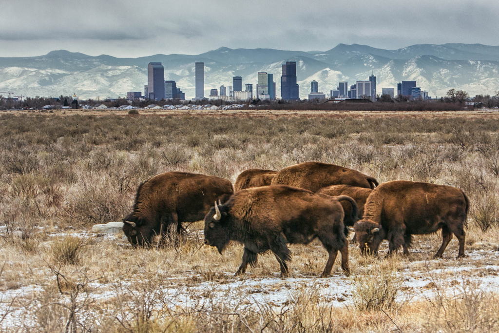
Bison and the Denver skyline, Rocky Mountain Arsenal, 2013. Photo by Hans Watson

What makes a wildlife refuge special?

Is it the ability to protect ecosystems and endangered species? Is it the protection of open space for recreational uses, like fishing and hiking? Is it the thought of keeping wilderness safe for future generations? How do the explosives fit in?

This is a very real question, and one that’s becoming increasingly relevant as the United States retires and reassigns the millions of acres of military land it acquired in the years surrounding World War II and the Cold War. In Indiana, the military history of Big Oaks National Wildlife Refuge is written in the 7 million inert projectiles with live fuses, 1.5 million rounds of unexploded ordnance, and 75,000 kilograms of depleted uranium remaining at the site. In Colorado, prairie species like the American bison are slowly returning after a multi-billion dollar remediation of contaminated soil and groundwater at the former Rocky Mountain Arsenal near Denver. Sites like these can be important to conservation efforts, but behind new visitor-friendly goals belie complex histories that can’t be ignored, as David Havlick discusses in his 2014 paper “Opportunistic Conservation at Former Military Sites in the United States”.

Reusing military land for public use isn’t a new idea, but Havelick may be the first to comprehensively discuss the challenges faced by wildlife refuges struggling to contend with their military past, and the opportunities they offer for conservation.

Military to wildlife refuge conversion (sometimes abbreviated as M2W) can, in theory, work well both for the American people and the Department of Defense: since the military is responsible for paying for and carrying out remediation of retired bases, it’s far better for them to find a use that allows them to avoid the painful process of combing the entire base for hazards in preparation for construction. Instead, officials can focus on the areas where the contamination poses a risk to the public, and leave the rest as it is. Once these sites have been remediated, they’re usually turned over to the Fish and Wildlife Service for management. The United States has closed or reassessed over 400 military operations in the past quarter century, and EPA projections indicate that an attempt to fully remediate all 16,000 contaminated military sites in the country would constitute the largest remediation project in the U.S. government’s history. With M2W, the military offloads unwanted land while limiting expenditures, simultaneously providing open space for the public and supporting local ecosystems.

The sites’ military history doesn’t disappear when they’re declared wildlife refuges. At Big Oaks, rolling grasslands cleared by decades of munitions testing now support native birds and reptiles found nowhere else in the state. To maintain these grasslands, refuge workers conduct regular prescribed burns to decrease the risk of catastrophic wildfires. Because of the site’s history, however, conventional burn methods were deemed too dangerous given the presence of undetonated bombs, shells, and grenades. Instead, refuge workers experimented with ignition by remote-control helicopter rather than using human pilots. In the case of an accidental detonation, at least no human would be harmed.

Paradoxically, the presence of these dangers can protect wildlife; one refuge official pointed out that “From an enforcement and public education standpoint, it’s much easier to keep people out of refuges when there’s a public safety concern, such as UXO [unexploded ordnance] than for biological reasons.”

Environmental accountability in the military is a relatively new concept. With few notable exceptions, awareness of how domestic military activities affect the environment really only began to develop in the 1960s and 70s, well within the lifetimes of many people alive today. For this reason, the actions taken at these sites establish an important precedent for how we deal with contaminated military areas in the future. Military to wildlife refuge conversion, if approached with the right intentions, can save deeply contaminated land. If approached with the wrong intentions, it can provide an environmental smokescreen that masks a history of military negligence. War has changed a lot in the past fifty years, but we’re still living with the environmental consequences of previous generations’ choices. We have the chance to revisit those choices and at least try to make them right, by engaging with these sites’ military histories rather than obscuring them. If we don’t, future generations will suffer for it.

Will Women Survive the Incoming Storm?

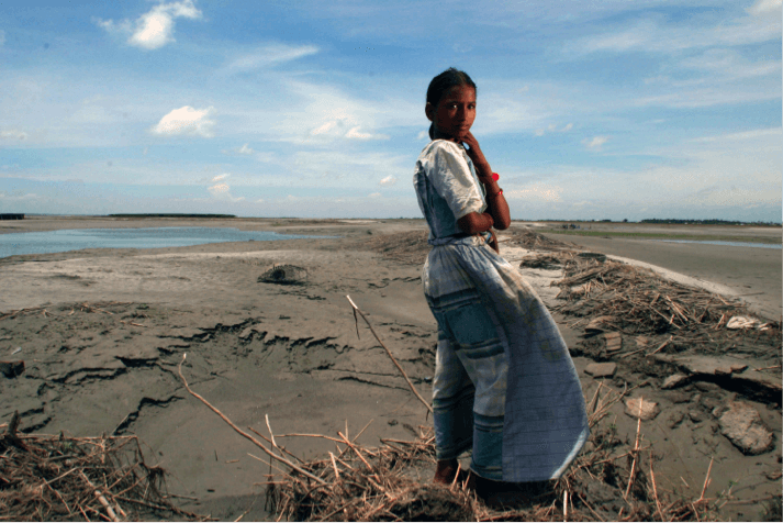
Woman on sandy char with the wind on her back.

A woman stands with her back against the wind on a small char island in Bangladesh.

Source: Bangladesh Climate Change Knowledge Network

On the evening of November 15th, 2007, a category-4 storm called Cyclone Sidr struck the low-lying coast of Bangladesh destroying everything in its path. The cyclone ravaged through 30 southern districts in both the Barisal and Khulna Divisions, where thousands of people lost their homes to strong 240 km/hr. winds, and countless others drowned and lost their lives to tidal surges 7 feet high. When the water receded, more than 3,000 individuals were dead, with over 65% of them women, and 5,000 more were missing (UNICEF Bangladesh 2007). Cyclone Sidr became one of the biggest tropical cyclones and one of the worst natural disasters to ever hit Bangladesh. Over 8.9 million Bangladeshis were affected by the storm, either through the loss of life, home, and livelihood, with women being the most disproportionately affected.

After the storm various researchers began to look into the different ways vulnerable communities, especially those of women were affected by climate change. In January 2015, the International Policy Research Institute (IPRI) published a report, which served to highlight the different ways vulnerable communities in countries like Bangladesh are disproportionally affected by climate change. The report, titled “Climate Change Adaptation Assets and Group-Based Approaches: Gendered Perceptions from Bangladesh, Ethiopia, Mali and Kenya[1],” especially highlighted the ways in which women will be affected by climate change.

A map of Bangladesh that shows all of the in-country borders of Districts and Divisions

A country map of Bangladesh

Source: Ezilion Maps

In order to understand these impacts for women, it is important to visualize the country as a whole. Bangladesh is a lush, green, predominately agricultural country located in South Asia and is among the most densely populated countries in the world. Approximately 75% of the population lives in rural areas that are highly dependent on subsistence farming among other agricultural activities that are highly sensitive to the impacts of climate change. Among these people is Swapna Begume. She has been living in her small town, South Kainmari, located in the Khulna Division of Bangladesh. She recalls Cyclone Sidr as a traumatizing experience, because even though they are constantly affected by natural disasters, like cyclones, the events are becoming much more magnified and destructive than ever.

The climatic changes Swapna talks about are just a few of the kinds of events the International Policy Research Institute addresses in their report. They include the possibility of a scenario with high emissions (more than 12,000 parts per million of CO2 equivalent), where global average sea levels could increase by approximately one meter by the end of the century. This would send a good portion of Bangladesh’s coastline underwater, and flood areas surrounding the over 80 rivers and tributaries running through the country! Not only so, climate change, or sea level rise in particular, would also increase the rate at which many of the riverbanks along the three main rivers, the Brahmaptura, Ganges, and Meghna, are eroding. Furthermore, extreme weather events, such as massive flooding, killer cyclones (like Sidr), destructive storm surges, devastating droughts, heavy monsoon downpours, and deadly salinity intrusion can all further damage crops and undermine the already fragile livelihoods of most coastal communities.


Lots of people are standing at the edge of an eroded riverbank

A community stands at the edge of an eroded riverbank in Bangladesh

Source: South Asian Disaster Knowledge Network

Women are at the forefront of the effects of these issues, especially in rural communities. More recently, there has been an influx in the number of male heads of households moving from the coastal regions of Bangladesh to urban areas. What this means for women is that they are then left behind to help keep everything, property and crops, afloat. When river erosion causes the main riverbanks to disappear, the only buffer or protection between coastal villages and flooding sources is destroyed. Furthermore, in the case of disaster, the female head of the household has the responsibility to secure the safety of everyone and everything before she can think of herself. After disasters, even if a woman survives, if her husband or father is killed during a natural disaster, she can lose access and ownership of her property, due to gender biased inheritance and family laws, lack of information about legal rights, and inability to access the justice system. For women in Bangladesh, control over assets and property is highly dependent on gender, which almost always favors men, so women are forced to attempt to survive in the harshest of conditions. Climate change also plays a huge role here because the impacts are expected to magnify the intensity and frequency of destructive storms like Cyclone Sidr. Swapna remembers that during Cyclone Sidr she was forced to decide whether she would save herself and her daughter or attempt to collect and safeguard her sheep and home.

Moreover, for those, like Swapna, who heavily rely on natural resources for survival, their ability to find resources and ways to adapt to climate change impacts is hindered by their gender. In a traditional society, like the one that exists in Bangladesh, women are often not allowed to be part of public conversations and are, therefore, less likely to receive critical information for emergency preparedness. The desire to gather the knowledge and tools in preparation for climate change is present in communities of women; the only thing missing is data that will support this will. The International Policy Research Institute included a very important point: adaptation strategies are defined by the way both men and women’s ideals intercept and intertwine with each other. However, with the current lack of information on the impacts climate change has on women, adaptation strategies will not be inclusive of women’s needs.


[1] Aberman, Noora-Lisa; Ali, Snigdha; Behrman, Julia A.; Bryan, Elizabeth; Davis, Peter; Donelly, Aliveen; Gathaara, Violet; Kone, Daouda; Nganga, Teresiah; Ngugi, Jane; Okoba, Barrack and Roncoli, Carla. 2015. Climate, change adaptation assets and group-based approaches: Gendered perceptions from Bangladesh, Ethiopia, Mali and Kenya. IFPRI Discussion Paper 1412. Washington, D.C.; International Food Policy Research Institute (IFPRI). http://ebrary.ifpri.org/cdm/ref/collection/p15738coll2/id/128950

Race, Place, and Money: The Disparities of Lead Contamination

Community members in Southeast Los Angeles protest for the permanent closure of Exide Technologies in Vernon.  Photo credit: Idalmis Vaquero

Community members in Southeast Los Angeles protest for the permanent closure of Exide Technologies in Vernon. Photo credit: Idalmis Vaquero

Just two miles from Exide Technologies in Vernon, California, a young Latina girl picks up some soil while playing at Salazar Park. Her mother immediately drops her work, and takes her daughter home to wash the soil off her hands. Why did she need to wash her daughter’s hands? State officials have told people in Southeast Los Angeles to keep children from playing with soil- testing has shown elevated lead levels in the soil near Exide’s Vernon facility, a lead smelter that has a chronic history of environmental violations.

A recent study published in the Environmental Geochemistry and Health Journal by Aelion et al., highlights the social inequities of lead exposure that are seen in this case. The study found that Black and Latino low-income children living in urban areas are at a greater risk of exposure to lead in soil compared to White children who come from a more affluent backgroud. The study examined two rural and two urban areas in South Carolina and found a relationship between lead exposure based on race, ethnicity, income, and geographic location.

Although legislation passed in the 1970s banned lead-based paint and leaded gasoline, exposure to lead is still a major public health issue, especially in recent years where over 177,000 children had blood lead levels above 5 micrograms per deciliter. Although 5 micrograms per deciliter sounds like a small dose, the effects have huge consequences.  Lead exposure has been linked to impaired brain development in the early years, negative neurological outcomes, lower IQ, behavioral problems, and hearing impairments. According to the Centers for Disease Control and Prevention, there are no known safe blood lead levels in children and lead exposure is entirely preventable, which means more should be done to protect all children.

So why are some children more at risk that others? These are some reasons the study by Aelion et al. found:

  1. Race matters.

Aelion et al. point to race as an important determinant of lead exposure, with Black and Latino communities having a higher risk. This is partially due to the racial residential segregation that still exists in the United States today. To provide some context, 85% of residents living in Southeast Los Angeles are of color and 69% of those are Latino. Residential segregation, on average, affects access to employment opportunities, the quality of housing and neighborhoods, and the access and quality of medical care. These factors raise the likelihood that a person works at a facility that handles lead, a family lives in housing with lead-based paint, and a family lacks access to blood lead testing and medical treatment for children with possible lead poisoning.

  1. Low-income, high risk.

It is also important to note that many racial and ethnic minority individuals are also low-income. The study by Aelion et al argues that the combined association of race and a low income creates an even higher risk of lead exposure in children. In addition to being a predominately Latino community, 55% of the households in Southeast Los Angeles live 200% below the national poverty line. Low-income communities generally have less social participation given a higher concern to meet basic needs, which means people are less likely to demand lead clean-up in their communities even if there is contamination. Some families also tend not to address lead contamination, because it is a costly issue that does not have the most immediate or obvious effects.

  1. Urban areas mean more lead.

According to Aelion et al., urban areas have higher concentrations of lead since they generally have more potential sources of pollution. Congested roads with a legacy of leaded gasoline, housing units built before the 1970s with lead-based paint, and industries that handle lead increase the pathways by which the pollutant can enter a child’s body.

The threat of lead contamination is even more serious in Southeast Los Angeles. There are 9 lead emitters in Southeast Los Angeles, one of which is Exide, a facility that has over a dozen of environmental violations for emitting high levels of lead into the air, water, and soil nearby. Los Angeles also has a many roads and a substantial amount of housing built before 1970s.  The simple fact that a child lives in an urban environment contributes to a higher risk of lead exposure. However, it is important to recognize that all of these factors are interconnected; low-income children of color also tend to live in inner cities.

Fortunately, there are environmental justice organizations that are addressing the various dimensions of this problem.  Organizations, such as Communities for a Better Environment (CBE) and East Yard Communities for Environmental Justice (EYCEJ) in Southeast Los Angeles tirelessly fought for the closure of Exide Technologies and are currently fighting for the cleanup of the homes affected.

But, this is not just about Los Angeles or South Carolina.  There is a strong awareness that the fight to reduce lead exposure is not yet over.Communities around the country affected by unjust lead exposure should know that they are not alone; our children’s futures depend on our efforts to demand a safe environment for them to live and play in.

Working to Get Leatherback Turtles Off of the Endangered Species List


The largest turtles on earth, leatherback turtles can be traced back to a family of turtles that existed 100 million years ago. With soft, rubbery shells measuring up to seven feet in length, these unique and historic creatures are easily identifiable. Over time, however, leatherback turtles are seen less and less often. In 1970, the species was deemed endangered- a label it continues to carry today.

A leatherback turtle gliding through the water

http://nmlc.org/wp-content/uploads/2011/07/leatherback.jpg


There are many reasons why the leatherback turtle population is declining: the destruction of coastal nesting habitats, the frequency with which turtles drown in fishing nets, the Malaysian preference for turtle eggs as sources of nutrition, and the inability of turtles to tell the difference between their main food source and plastics, to name a few.


For humans, particularly those who rely on fish as sources of income or food, the loss of the leatherback turtle will have serious repercussions. The turtles’ main source of nutrition is jellyfish. The loss of the leatherback turtle population would cause a burgeoning of the jellyfish population. Because jellyfish feed on fish larvae, the populations of commercially popular fish could decline, impacting fishermen and consumers, thus impacting our economy.


Leatherback turtles need human help, and there are many ethical reasons why fishermen should answer their plea. For starters, there is a historical aspect to the species existence. Leatherback turtles were on this earth well before humans were and only began their steep decline with the existence of humans. Because fishermen are the primary reasons why leatherback turtles are disappearing, it is their responsibility to clean up the mess that the majority of them have made. Furthermore, leatherback turtles play an important role in various ecosystems worldwide, and healthy ecosystems contribute to large economic gains, particularly in the fishing industry.


While we must work to ensure that the fishermen do not accidently kill the turtles that help maintain their jobs, we must not shy away from putting in effort to expand leatherback turtle populations worldwide.


Compound Risks and Resiliency: Why U.S. Coastal Cities May Not Be Doing Enough to Strengthen Resilience against Climate Change

Source: Flickr

Flooding paralyzes lower Manhattan during Superstorm Sandy (Photo courtesy of Flickr)

On August 29, 2005, Hurricane Katrina slammed into the Gulf Coast, unleashing winds of 125 mph, record-breaking storm surge and heavy, persistent rainfall. The storm was particularly devastating for New Orleans, where conditions overwhelmed the city’s inadequate flood-protection system, inundated entire neighborhoods and displaced up to 400,000 residents. Seven years later, Superstorm Sandy roared up the East Coast, bringing extreme storm surge and eventually becoming the second costliest natural disaster in U.S. history behind Hurricane Katrina. As damaging as Sandy was, however, the storm could have been many times more destructive than Katrina. The reason? While Katrina brought with it great storm surge and heavy precipitation, Sandy actually produced very little rainfall. The significance? New research now suggests that major U.S. coastal cities are increasingly at risk of storms that produce both strong storm surge and rainfall. Consequently, over 123 million people, or nearly 40 percent of the U.S. population who live along the coast are now much more likely to experience destructive storms more like Katrina than Sandy.

In a new study published in Nature Climate Change, researchers have found that the odds of an event similar to Hurricane Katrina have since doubled for cities like New Orleans and New York in the past 30 years. Based on historical data, the study finds that storm surge and heavy precipitation, two mechanisms by which flooding in coastal zones can occur, are not only increasing, but are also occurring together as a result of climate variability and change. According to the study, the frequency of this phenomena, known as compound flooding events, has been rising over the past three to four decades in six major U.S. coastal cities (New York City, San Francisco, San Diego, Boston, Los Angeles and St. Petersburg).

Hurricane Katrina was a drastic example of a compound-flooding event that caused inadequate infrastructure such as levees and floodwalls to breach and crumble due to the dangerous combination of heavy storm surge and significant rainfall. Meanwhile, Superstorm Sandy, which had significant storm surge as well, hardly produced any rainfall and was therefore not a compound flooding event. If Superstorm Sandy had been one, the loss of life and damage could therefore have been significantly worse for millions who reside on the East Coast. By the same token, however, because compound flooding events are indeed occurring twice as often in the last 30 years for coastal cities, then NYC and other coastal cities should expect and prepare for Katrina-like events.

Despite this meteorological difference, both Katrina and Sandy also demonstrated that the impacts of severe flooding, whether caused a by compound event or not, are disproportionately borne by low-income and minority communities. Following Katrina, one-fifth of those displaced by the storm were likely to have been poor and African Americans alone were estimated to have accounted for 44 percent of the victims. Following Sandy, African Americans and Latinos were found to have disproportionately resided in census tracts within three miles of the storm surge. Storm surge is especially damaging since it also causes overflow of industrial waste sites and contamination of water supplies-many of which belong to low-income and minority groups. When combined with a heavy precipitation event, where rainfall overflows sewers and storm drainage systems, the impacts of storm surge on low-income and minority communities can be exacerbated.

In the aftermath of both storms, these two cities have responded by improving resiliency including efforts building community preparedness against future storms and promoting long-term sustainability. After 10 years of rebuilding since Hurricane Katrina, the city of New Orleans has bounced back, regaining up to 90 percent of its population since the storm hit and building its resilience against the impacts of future storms. Meanwhile, NYC is undertaking rigorous efforts to build a stronger, more resilient community to prepare for future risk. Yet, as this study illustrates, it is becoming increasingly likely that NYC will soon have a Katrina-type event in its future. Therefore, NYC and other major cities must quickly learn from the lessons of Katrina, recognize the disproportionate impacts that people of color face from extreme weather events and continue to strengthen resilience to meet these increasing risks. With a more accurate gauge of the risk, cities should therefore reflect these growing understandings of climate change and its subsequent impacts.

Living in New York City is More Sustainable…Right?

Time Square in New York City

Photo taken by JoeyBLS Photography (Flickr.com)

By Alisha Pegan 9/23/2015

We have heard the case that living in a big city is one the “greenest” things you can do, especially in a megacity, or giant city, like Cairo, Tokyo, or New York City. The common assumption is as more people live in an area, then the less resources they use collectively. But is that true? In 2015, a group of international scientists released a groundbreaking report that answers this very question. They quantified the electricity use, water consumption, and waste generation for the world’s top 27 megacities. These cities include London, Beijing, Mumbai, New York City, and more, all with over 10 million people. The goal of the paper was to investigate how density, economic activity, and population growth affect the use of energy and resources, as well as confirm whether megacities are beneficial for sustainability.

3 tables comparing the resource and energy flow for 27 megacities

Resource flows for megacities in 2011. (A) Energy use. (B) Water use including line losses. (C) Municipal solid waste production. Values shown are for the megacity populations scaled on a per capita basis from recorded data for the study area population (Methods). Source: Energy and material flows of megacities. http://www.pnas.org/content/112/19/5985


What did they find? New York City is far from sustainable in comparison to its counterparts. It uses more energy and water and produces more waste than any other megacity in the world. To give some context, annually, New York City (pop 22.2 million) uses 2,824 petajoule (PJ) which is equivalent to New York consuming one supertanker full of oil every 1.5 days. The image below can give a sense of scale for a super tanker.

Image of a super tanker greater than 400 meters long.

Comparison of a Knack Nevis supertanker to some of the tallest skyscrapers.


On the other end of the spectrum is Kolkata, India (pop 16.3 million) which uses only one-thirty-sixth as much energy as NYC! To make it worse, New York City consumes 10.9 million megalitre of water in comparison to Jakarta, which consumes a low of 0.48 million megalitre. To top it off, the waste New York City produces is at least double that of all other megacities with approximately 33  megatonne per year in comparison to Dhaka with approximately 1 megatonne per year. New York City is one gluttonous city!

This is not to say that all developed megacities consume, use, and dispose the most, only the megacities in the United States do. Basically, New York City and Los Angeles are energy and resource hogs. Megacities in other developed nations, such as London, Moscow, and Tokyo have undertaken governmental conservation strategies to use less. For example, London decreased electricity usage as a result of a 66% increase in price, energy efficiency in buildings and appliances, and public awareness throughout the city. Moscow is serviced with district heating systems, meaning it uses waste heat from electricity generation. Tokyo has managed to reduce its water leakage rate to only 3% by replacing pipes and improving pipe material.

Based off the previous information, there is no evidence that megacities are sustainable since there is so much variance from city to city. You can, however, assess if you are living in a “green” megacity. First, look at how much land you have. Urbanized land (total developed land) per person and residential floor area per person are useful indicators for energy and electricity use. Therefore, any megacity that builds upwards instead of outwards uses less energy and electricity. Second, look at how much building space you have. Area per capita correlates with water consumption per capita, so in this case, residents in Los Angeles and New York consume more water because they have more building space. So, if you have a bigger house, you will use more water. Third, look at how much money you have. The study found that waste and emissions go up with Gross Domestic Product (GDP). Electricity, transportation, and waste disposal significantly increased because of growing GDP.

It really matters where you live if sustainability is your life’s concern. While you can make it a priority to live a “green” life, where you live will strongly affect  your energy and resource consumption. So, nope, you’re not doing us all a favor moving to New York City. Maybe move to Jakarta instead.

“Sweet Dreams are Made of REEs” Study shows that green technologies are revolutionary, but their production poisons local communities with toxic wastes

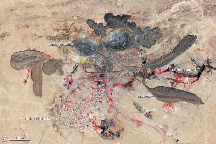
Clean technologies depend upon raw materials from mining operations such as the one pictured above in northern China. The black regions are sites of toxic waste created by the mining process. These toxins leach into local soils and foods, and eventually pollute the bodies of local residents.

Green, renewable, and sustainable. These words are frequently used to describe the solar panels, wind turbines, and electric cars that will fuel the future’s energy industry. But did you know that these “clean” technologies are responsible for increased rates of leukemia, mental disability, and toxic poisoning? While green technologies do not pollute the air like a coal-fired power plant, their manufacture requires toxic materials that threaten the health of local mining communities. These toxic materials are known as rare earth elements (REEs), seventeen specialized metals with unique physical and chemical properties. The services provided by the toxic REEs are so unique that no substitutes exist to replace them, meaning they remain essential components of many green technologies.

Despite their name, rare earth elements are not “rare” at all. In fact, they are more common than gold and can be found throughout the Earth’s crust. REEs are “rare” because they exist in concentrations so low that they are difficult to extract profitably. Only a few countries—such as Russia, Brazil, China, and the U.S.—possess deposits with REE concentrations high enough for human use. Unfortunately, mining these deposits poses both environmental and human health risks. The mining wastes contain traces of the toxic REEs. REEs are chronic toxins – that is, over the course of many years, they pollute the kidneys, liver, and lungs.

In 2013, a new study by China’s Fujian Normal University became one of the first to directly quantify the human health threats posed by REE mining operations. To do this, the study surveyed a farming community in southeast China (Fujian Province) that is adjacent to a REE mining facility. Health concerns related to REE mining are particularly pertinent to China, which supplies 86% of the world’s REEs and lacks adequate implementation of environmental and health safety regulations. The study compared the presence of REEs in the environment (soil, crops, and water wells) with REE concentrations in the bodies of local residents who ate locally grown produce (human hair and blood samples).

The study found that Fujian’s soils had high concentrations of toxic REEs, compared to areas without mining operations. Over half of the toxic waste in Fujian’s soil pose little risk to human health, because they attach to clay minerals in the earth. The other half, however, is bio-available; that is, REEs can be freely absorbed by vegetation. As such, locally grown crops absorb some, though not all, of the REEs present in the soil. The study found that local crops in the surveyed area had elevated levels of REE, though not at concentrations above estimated daily intake. Daily intake is the suggested amount of pollutant that is deemed “safe” for human consumption. Certain vegetables with high water contents, such as taro and water spinach, had much higher levels of REE compared with other locally grown foods. While these levels are low, long-term exposure may still cause significant harm, especially to children and infants, who are more vulnerable to the effects of toxic chemicals.

Much like the deadly chemical DDT, REEs can be particularly dangerous toxins because they persist in the bodies of living things for years at a time. This process is known as bioaccumulation, and is particularly dangerous, because plants and animals, including humans, can collect small, harmless doses of chemicals in their bodies over a period of years, until the concentration of chemicals becomes harmful. This is why human breast milk is considered slightly toxic: chemicals that the mother bioaccumulated throughout her lifetime can transfer to her infant through breast milk. Similarly, REEs can persist in the human body for over fifteen years.

The Fujian study demonstrates that while consuming crops with REE concentrations may not be dangerous on a daily basis, the chronic accumulation of REE over many years, especially for young children, presents significant health risks. These risks are already surfacing at Fujian: local residents had elevated REE concentrations in their blood and hair samples. Other environments more heavily polluted by REE mining may already be at risk of health damages, including lower kidney functioning and lung disease. For example, in northern China, where two-thirds of REE mining and processing takes place, REE concentrations in local soils were up to 130 times greater than polluted soils in Fujian.

Unfortunately, toxic REEs can enter the body from many sources. These “exposure pathways” include eating contaminated food, drinking polluted water, and breathing or touching REE particles in the air. While REE pollution from only one of these sources may be considered “safe,” the cumulative impacts of multiple sources pose significant threats to human health. For example, in one East Asian mining community, some houses were just 20 meters away from REE manufacturing facilities. After the mine’s arrival, a significant number of community members contracted, and died from, leukemia, and several local children were born with severe mental disabilities.

On a global scale, green technologies promise to address serious environmental problems, such as global warming, by cutting the carbon emissions from dirty industries. However, are these technologies really “green” if they depend upon the pollution of local communities? To be truly “clean,” solar panels and wind turbines cannot ignore their origins. A green and healthy future should be available to all communities.

Mobilizing Resiliency: Protecting Mobile Home Communities through Social Ownership

A photo of a row of mobile homes on an Appalachian hillside

A view of an Appalachian mobile home community. Source: Interpopulus.

Graphic breaking down mobile home community statistics


Trailer parks have emerged as symbol of personal failure in the United States, yet more than 20 million people live in mobile homes today. Are these 20 million Americans really failing, or is our understanding of mobile home communities the problem?

Despite social stigmas against “trailer parks”, studies have shown that residents are overwhelmingly satisfied with life in their mobile homes. Especially in the rural US, where over half of all mobile homes are located, these “trailer parks” play an important role in establishing communities. In a rural landscape, mobile home communities can bring together people who share similar backgrounds and ideologies, forming a strong sense of community and support. In fact, sociologists and community planners have noted that mobile home communities may be the “last genuine communities in America.”

However, because the majority of mobile home communities are for-profit, privately-owned enterprises, owners can subject residents to undemocratic and unpredictable management. Although many people in mobile home communities own their homes, they only rent the land they rest upon. On a whim, a landlord can uproot a decades-old community when another business model becomes more lucrative. As urban sprawl causes rural property values to steadily increase, these landlords are telling communities of mostly working-class and elderly residents to leave.

But in a recent study, a group of researchers from Appalachian State University show how mobile home communities can protect themselves through social ownership models. Specifically, the study focuses on Mark Park– a mobile home community of primarily Latin@ residents located within the town of Burnsville, NC that resisted the sale of their community by purchasing it themselves.

The study is especially important for Latin@ mobile home communities throughout Appalachia. In Burnsville, Latin@s only make up 4 percent of the community, whereas 95 percent of the population is white. Throughout Appalachia, this demographic is common, as people of color only make up a small fraction of the predominately white demographic. Yet, Latin@ communities have needs, cultural values, and languages that differ from those of white, Appalachian communities. By forming their own mobile home community, Latin@ residents can work together and support one another as they navigate a region that does not always represent them or their culture.

The focus of the study, Mark Park, is a primarily Latin@ community of 13 homes which rest upon an Appalachian hillside. The study shows how Mark Park can be a model of action for similar mobile home communities throughout Appalachia. To protect and gain ownership of their community, the residents of Mark Park established a land trust called the Burnsville Land Community. Through the land trust, they established a non-profit organization led by a Board of Trustees that oversees the land, facilities, finances, and infrastructure of the community. The non-profit collects rent from community members, and it also takes charitable donations and assistance from other non-profits in order to operate sustainably.

For Mark Park, a local non-profit called the Community Re-investment Association of North Carolina (CRA-NC) played an important role in establishing their land trust. After the residents of Mark Park failed to secure a loan from local banks to establish their trust, CRA-NC agreed to provide the community with a 0% interest loan that allowed them to purchase the land.

The study shows that establishing the land trust has made noticeable impacts on the livelihoods of the residents of the mobile home community. Not only has the agreement eased fears of displacement, but it has also inspired residents to put more work into their homes and their community, both individually and collectively. Because the land trust provides members with a $300 loan for home-improvements, many residents have started renovating parts of their homes, something they would have otherwise been unable to afford.

One resident noted that he was inspired to make improvements to his home because he now feels “protected” thanks to the trust. In addition, the Burnsville Land Community has invested in improving in its roadways, utility systems, and erosion issues that were previously jeopardizing the community. “We got a better community from the project… The people is working more together than they was back then [sic],” another resident noted.

For the millions of people across the US who currently live in mobile home communities, the Burnsville Land Community can be used as a model for change. By joining together, they can defy the negative stereotypes that too often peg them as “failures” and “trailer trash”. Instead, mobile home communities can use their collective strength to take back their communities and their identities.


From: Milstead, T.M., Post, J., Tighe, R., Ramsey, D. Preserving Appalachian mobile home communities through social ownership models: a case study of the Burnsville Land community. J Rural Community Dev. 2013;8:48–61.