A while back Chris Stringer linked to a wonderful interactive map on twitter.
Still being updated, a great resource by @nickyrozenblatt mapping published ancient genomes + sources https://t.co/WFCZRNOw8O
— Chris Stringer (@ChrisStringer65) December 12, 2018
The map, put together by Nicky Rozenblatt, is an attempt to curate current ancient DNA (aDNA) samples (link: http://umap.openstreetmap.fr/en/map/ancient-human-dna_41837#3/23.41/91.88). A quick overview of the Eurasian/African portion of the map reveals a clear distributional pattern. Most of our current aDNA comes from mid/high latitude parts of Eurasia. If you look only at the more ancient samples, this becomes an even starker contrast. There are clear preservation reasons for this. DNA appears to preserve best in cool/cold/stable/dry conditions. These traits are more characteristic of mid-latitude Eurasia than southern Eurasia, the Middle East, or Africa. It also is the case that there is a substantial historical bias in fossil/ancient skeleton retrieval from Europe, particularly European cave sites (Athreya & Ackermann, 2018).
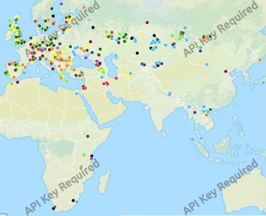
Map of ancient DNA (aDNA) localities across Africa & Eurasia (~2018)
We have learned, in just a little over a decade, a huge amount about human evolution from aDNA. Much of what we have learned has been surprising (at least in some corners of the paleonanthropological world)! Neandertals and those fossils we tend to identify as early “modern” humans, or Homo sapiens, interbred! There was this population of hominins distinct from Neandertals called, after the Siberian cave in which they were first identified (on the basis of genetic variation), Denisovans. We interbred with them, too! And Neandertals and Denisovans interbred with each other! And maybe other lineages that we may or may not have names for as of yet. It goes on…
For someone honed in fossil work, this level of specificity in population relations and events is stunning. So, too, has been the ability to use genetic data to generate semi-independent sources of dates, something that is always a confounding issue in paleoanthropology.
But the above map is weird, too. It is weird, because for the most part, it is pretty blank in the places we think most hominins lived. To give at least one perspective on this, here is a map from a paper by Hughes, et al. (2007) based on a probabilistic, biogeographic model of hominins expansion in the Pleistocene. The darker shaded areas are places with a high likelihood, based on their model, of hominin presence. I tried to produce an overlay of the two, but they are based on different renderings of the globe. Nevertheless, the contrast is clear.
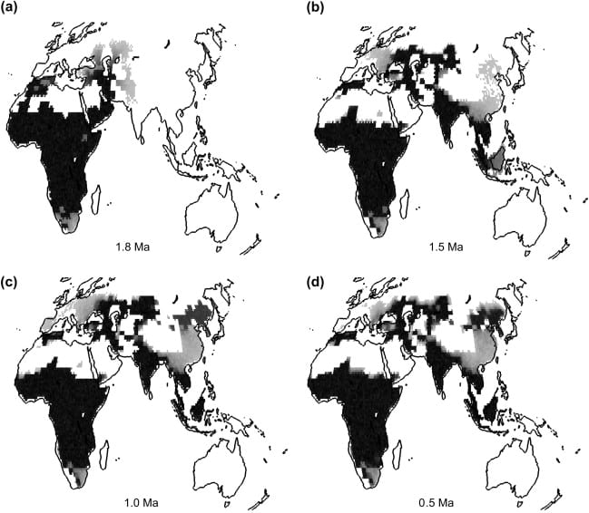
Four renderings of hominin occupation likelihood across the Pleistocene (Hughes, et al., 2007)
The vast majority of our evolutionary story takes place within the continent of Africa. This was pretty much always the case. John Hawks recently gave a lecture at the ASHG meetings that emphasized this point.
When people talk about this phase of human evolution that began two million years ago, they nearly always focus on stories of colonization. The story you hear is that hominins left Africa. I’ve seen it hundreds of times, from scientists as much as from journalists. What gets lost is that the mainstream of human evolution remained African this entire time.
Population geneticists have long observed evidence for much greater effective population sizes in Africa than in either Europe or Asia (likely greater than the sum of those two regions for much, if not all, of the Pleistocene). Eller (2001) provides a review of some of these understandings going back to an immediately pre-genomic era. Even outside of Europe, the most abundant fossil samples of hominins until pretty late in the Pleistocene come from tropical areas of SE Asia that are also pretty blank on the aDNA map.
What does it mean that this incredibly rich source of data derived from aDNA covers an area that does not match up all that well with the known distribution of hominin fossils? What about hominin archaeological evidence of occupation? Each of these three kinds of data, fossils, aDNA, and archaeological materials, provides unique and contrasting, but also partially overlapping kinds of information. In other words, the provide evidence to address evolutionary hypotheses about our past in slightly different kinds of ways.
So…what does the above contrast mean? I don’t have an answer to that, and for the moment, I’ll just leave the observation here. In the next couple of weeks I’ll be circling back to this post with some thoughts on the implications of this discrepancy and what it might mean for what we know, don’t know, and what how new observations might alter these understandings in surprising (or not surprising) kinds of ways.
Works Cited:
– Athreya, Sheela, and Rebecca Rogers Ackermann. “Colonialism and narratives of human origins in Asia and Africa.” (2018).
– Eller, Elise. “Estimating relative population sizes from simulated data sets and the question of greater African effective size.” American Journal of Physical Anthropology: The Official Publication of the American Association of Physical Anthropologists 116.1 (2001): 1-12.
– Hughes, John K., et al. “Investigating early hominin dispersal patterns: developing a framework for climate data integration.” Journal of human evolution 53.5 (2007): 465-474.
“Population geneticists have long observed evidence for much greater effective population sizes in Africa than in either Europe or Asia (likely greater than the sum of those two regions for much, if not all, of the Pleistocene)”
I can understand Europe and northern Asia being sparsely populated, given the colder climate, but why wouldn’t the Indian Subcontinent and Southeast Asia be just as densely populated as Africa? How was the climate and enviornment that much different than Africa?
South Asia quite likely was populated (though it lacks much of a fossil record). But Africa is simply much larger than South Asia. South Asia covers about two million square miles. Africa is nearly six times that size. Even if they were populated at an equal density, the census size within Africa would be much larger.
Those material evidences are obvious that Balkan was not a Gateway but the cradle of humanity and civilization. So, the whole Out of Africa hypothesis now seams in vain.
Interbreeding and the Theory of Evolution now have more proofs. Your priceless investigation and work probably should go in that direction?
The petruous bone has been a great vault for aDNA, and that in surprisingly warm climates. Expectation has been that warm climates degrade DNA too much too fast for good aDNA. Still, a very few anatomically modern samples from Africa were analyzed. Some in Pacific Island samples (Vanuatu). There are a few Harappan samples that could be analyzed rumors that some have – but no pubs). Some countries have been holding on tight to their samples. So, mostly it seems to be a form of sampling bias.